UNM MARHES Lab: Dr. Rafael Fierro, Kevin Aubert, Isaac Seslar
UNM Computer Science: Dr. Matthew Fricke, Dr. Jared Saia, Dr. Melanie Moses, John Ericksen (PhD), Abir Islam (PhD), Julie Hayes (PhD), Carter Frost
UNM Earth and Planetary Sciences: Dr. Tobias Fischer, Dr. Scott Nowicki, Karissa Rosenberger (Masters), Samantha Wolf
Rochester Institute of Technology: Varsha Dani (Assistant Professor)
Affiliated Institutes: Santa Fe Institute, NV5
SKETCH Algorithm & Dragonfly UAVs
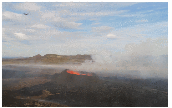
The team implemented SKETCH, a real-time boundary-tracing algorithm using two UAVs to detect and trace volcanic CO₂ plume edges. One UAV flies inside the plume boundary and another outside, adjusting paths based on real-time gas readings to maintain a “sandwich invariant.” Compared to a baseline single-drone strategy (ZIGZAG), SKETCH offered significant efficiency gains—shorter flight paths, less turning, and faster mapping times—without sacrificing boundary-tracking accuracy.
Field tests were conducted with physical Dragonfly drones in simulated and natural environments, including Balloon Fiesta Park and the Valles Caldera supervolcano in New Mexico. In simulation and real-world scenarios, SKETCH outperformed traditional mapping strategies, demonstrating robust performance even in complex multi-plume structures and narrow “dumbbell” configurations.
Gradient Descent and Rasterization Mapping
Earlier phases of VolCAN demonstrated the Dragonfly swarm’s ability to autonomously follow CO₂ gradients using a modified flocking algorithm, allowing UAVs to collaboratively locate emission sources. Rasterization techniques, including lawnmower and spiral search algorithms, were used for large-area mapping, while Kriging interpolation was applied to create CO₂ concentration heatmaps.
Impact and Future Directions
The VolCAN project reduces the risk to human researchers, improves temporal resolution in gas monitoring, and provides tools for better volcanic eruption prediction. The SKETCH system bridges the theory-implementation gap in autonomous boundary tracing and lays the foundation for future applications in environmental robotics, including hazardous leak detection and industrial monitoring.
For more information, visit: https://volcan.cs.unm.edu/
Leave a Reply